Data preparation for AI-fueled Geospatial Analysis
Its been ages since businesses, governments, researchers, and journalists are using satellite data that helps understand the physical world and take action. As the geospatial industry evolves, so are the ways in which geospatial professionals use data to solve problems. Satellite imagery contains information that is useful for data-related projects. That’s why we’re seeing the rise of AI and ML in this industry.
Geospatial intelligence provides geographical information and distribution of elements in a geographic space and is now an essential tool for everything, from national security to land use and planning to agriculture and a host of commercial and government functions.
AI and Computer Vision for Geospatial Analysis
Artificial intelligence (AI) is revolutionizing the field of geospatial analysis by providing advanced tools and techniques to process and analyze vast amounts of geospatial data. Geospatial data includes information about the Earth's surface, such as satellite imagery, aerial photographs, and geographic information systems (GIS) data.AI algorithms and computer vision techniques are used to extract meaningful insights from geospatial data. These technologies enable automated data processing, pattern recognition, and scalable analysis, significantly improving the efficiency and accuracy of geospatial analysis tasks.
One of the key advantages of using AI in geospatial analysis is the ability to process large volumes of data quickly. Traditional manual methods of analyzing geospatial data can be time-consuming and labor-intensive. AI-powered algorithms can analyze massive datasets in a fraction of the time, enabling faster decision-making and response. AI also enhances the accuracy of geospatial analysis by reducing human error and subjectivity. Computer vision algorithms can detect and classify objects in satellite imagery, such as buildings, roads, and vegetation, with high precision. This helps in various applications like urban planning, disaster response, and environmental monitoring. Below are a few applications of Geospatial AI which cater to many industries and use cases:
Object detection
One of the primary applications of AI and Computer Vision in geospatial and satellite imagery is object detection and recognition. Through deep learning algorithms, AI models can accurately identify and classify objects such as buildings, roads, vegetation, and water bodies in satellite images. This capability is crucial for urban planning, environmental monitoring, disaster response, and infrastructure development.
Classification
Another significant use case is land cover classification, which involves categorizing different land types based on satellite imagery. AI algorithms can analyze multispectral and hyperspectral data to identify land cover classes like forests, agricultural fields, urban areas, and water bodies. This information is vital for land management, ecological studies, and monitoring of changes in land use over time.
Anomaly detection
AI and Computer Vision also play a crucial role in change detection and anomaly detection in geospatial imagery. By comparing satellite images taken at different times, AI models can identify changes in the landscape, such as deforestation, urban expansion, or natural disasters. This helps in monitoring environmental changes, detecting illegal activities, and supporting disaster management efforts.
Furthermore, AI-powered image segmentation techniques enable the extraction of detailed information from geospatial imagery. For instance, semantic segmentation can accurately delineate different land cover classes within an image, while instance segmentation can identify and track individual objects or features of interest. These capabilities find applications in precision agriculture, infrastructure monitoring, and resource management.
Map better with Data preparation for Geospatial AI
Accurate training data is essential for geospatial AI applications to provide precise and reliable results to users. Geospatial AI involves analyzing and interpreting data related to geographic locations, such as maps, satellite imagery, and spatial databases. Training data acts as the foundation for training machine learning algorithms and models in geospatial AI systems. Here are the typical steps involved in data preparation for geospatial AI:
Data Collection
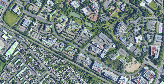
Data collection involves gathering relevant geospatial data from various sources. This can include satellite imagery, aerial photography, GIS databases, GPS data, sensor data, and user-generated content. The data collection process should align with the specific requirements of the geospatial AI application. For example, if the application involves mapping and navigation, data collection may focus on obtaining accurate and up-to-date map data, including road networks, points of interest, and traffic information. If the application is related to land use analysis, data collection may involve acquiring satellite imagery with land cover information. The goal is to collect a diverse and representative dataset that encompasses the geographical area of interest.
Data Curation
Data curation involves the process of cleaning, organizing, and preparing the collected geospatial data for training AI models. This step is crucial for ensuring the accuracy, consistency, and quality of the data. Data cleaning entails removing duplicate records, addressing missing or erroneous values, and handling outliers or noise present in the dataset. It may also involve standardizing the data formats, ensuring consistent coordinate systems, and resolving any inconsistencies or conflicts within the data. Additionally, data curation may involve preprocessing steps like rescaling or normalizing numerical attributes to facilitate effective model training. The goal of data curation is to create a refined and reliable dataset that is ready for subsequent analysis and model training.
Data Annotation
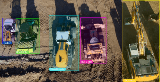
Data annotation is the process of labeling or tagging specific features or regions of interest within the geospatial data. It involves assigning semantic or spatial labels to the data to provide the necessary ground truth for training supervised AI models. In geospatial AI, annotation can encompass various tasks such as object detection, segmentation, classification, or tracking. For example, in satellite imagery, data annotation may involve marking buildings, roads, vegetation, or water bodies. In aerial imagery, it could involve labeling objects like vehicles, pedestrians, or buildings. The annotation process can be performed manually by human annotators with domain expertise or using automated tools in some cases. Data preparation services encompass various annotation techniques tailored to geospatial applications.
Polygon Annotation: Polygon annotation involves drawing and labeling polygons to outline and identify specific regions or areas of interest within geospatial data. This annotation type is particularly useful when dealing with irregularly shaped or complex features. In geospatial AI, polygon annotation is commonly used for tasks such as land cover classification, land parcel delineation, or delineating boundaries of administrative divisions. Annotators mark points on each end or edge of an object in an image or video, enabling precise location information.
Point Annotation: Point annotation involves marking specific points or coordinates within geospatial data. It is commonly used for tasks that require pinpointing precise locations or points of interest. For example, annotating specific addresses, landmarks, or geographic coordinates enables accurate geocoding, location-based searches, or geofencing.
Object Detection: Object detection involves identifying and locating specific objects or features within geospatial data. This annotation type typically involves drawing bounding boxes around objects of interest. In geospatial AI, object detection can be applied to various scenarios, such as identifying buildings, roads, vehicles, pedestrians, or other landmarks in satellite imagery or aerial photography. Object detection annotations enable AI models to recognize and locate specific objects accurately, supporting tasks like mapping, urban planning, and infrastructure management.
Semantic Segmentation:
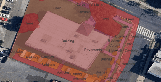
Image Classification: Image classification in geospatial AI enables tasks such as environmental monitoring, land use planning, infrastructure assessment, or change detection. It provides valuable insights and information by automatically categorizing and analyzing large volumes of geospatial data. Data annotation experts classify objects in images based on custom taxonomies, such as land, road, vehicles, residential properties, and more.
Conclusion
Data preparation plays a pivotal role in the success of geospatial AI applications, enabling accurate and reliable results in various geographic contexts. Geospatial AI relies on diverse and precise data, collected from various sources, to train models effectively. By emphasizing TagX's expertise in each step of the data preparation cycle, we demonstrate our ability to deliver high-quality geospatial AI solutions. Our proficiency in data collection, curation, and annotation ensures that the training data we provide is accurate, reliable, and tailored to meet the unique requirements of our clients. With our comprehensive data preparation process, we empower users to leverage geospatial AI effectively and achieve their goals with super-sharp results.