We are the worlds leading Data Provider
- 840, Harekrishna Vihar, Indore, India
- [email protected]
![[object Object]](/assets/img/hero/hero-shape-6.1.png)
Your Trusted Partner for Geospatial and Satellite Imagery Data Annotation from TagX.
TagX can help businesses in the geospatial industry by providing them with accurate and comprehensive annotations that enable their AI algorithms to better understand geographic data. With our annotations, businesses can unlock the full potential of geospatial AI and satellite imagery applications, including precision agriculture, urban planning, and disaster response. We have a team of experienced annotators who are well-versed in handling geospatial data and can provide high-quality annotations tailored to meet specific project requirements.

Data Annotation for AI in Geospatial Imagery
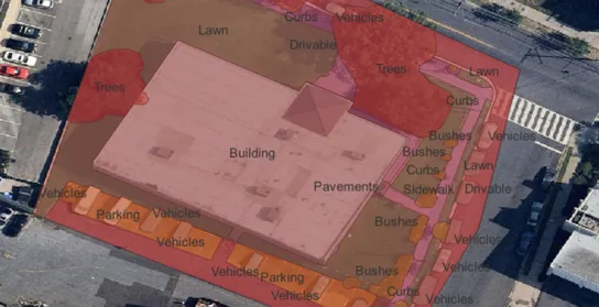
City Planning and Management
Artificial Intelligence (AI) can be used in city planning and management using aerial imagery to automatically analyze and extract valuable information from aerial images, such as identifying land use patterns, road networks, building structures, and changes over time. Satellite images of entire cities can be segmented by TagX with pixel-perfect accuracy for detecting buildings, roads, water bodies, and other lands. Other use cases include cloud detection, water bodies monitoring, as well as tracking changes in settlements and land use over time. This can help city planners and managers to make more informed decisions about urban development, transportation, and infrastructure.
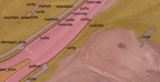
Construction & Mining
Aerial imagery and AI can help monitor construction and mining sites by automatically analyzing and extracting valuable information from aerial images, such as identifying changes in land cover, the progress of construction, and compliance with regulations. This can help construction and mining companies to better manage their operations, while regulatory agencies can ensure compliance with regulations. TagX provides annotation of geospatial data which is then used to train machine learning models that can automatically analyze new aerial images and extract valuable information.
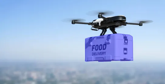
Autonomous Drones
AI-enabled drone applications use artificial intelligence to enable drones to perform various tasks such as autonomous navigation, object detection, and decision-making. Drones equipped with AI-enabled applications can be used for a wide range of applications such as agriculture, construction, search and rescue, and surveillance. Semantic segmentation and polygon annotation by TagX can be used to recognize a wide range of features and scenarios, such as different types of objects, terrain, and weather conditions. This can help drones to navigate autonomously, detect objects, make decisions in real-world environments, and have a safe landing.
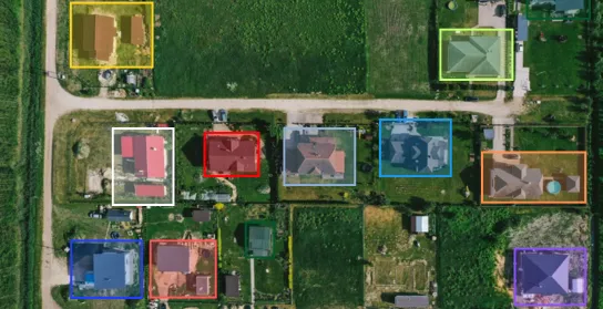
Disaster Management
Geospatial AI can help in disaster management by automatically analyzing and extracting valuable information from geospatial data, such as satellite imagery, aerial images, and GIS data, to support decision-making during disaster response and recovery operations. TagX provides labeled datasets to train AI models for smart disaster management. By using data annotation, geospatial AI systems for disaster management can be trained to recognize a wide range of disaster-related features, such as damaged buildings, blocked roads, and flood-affected areas. This can help disaster management authorities to make more informed decisions about resource allocation, evacuation, and recovery operations.
Types of Annotation
With Tagx, your AI applications will recognize and identify objects at unmatched speed, improving your models predictions and confidence levels. We understand that different AI use cases require different types of data annotation to achieve optimal performance. TagX offers a wide range of annotation services for image, text, audio, and video data, as well as 3D point cloud and LiDAR annotation. We pride ourselves on delivering high-quality annotations with precision and accuracy to ensure that your AI models can perform at their best. Whatever your use case may be, you can count on us to provide the right type of annotation to meet your specific needs.
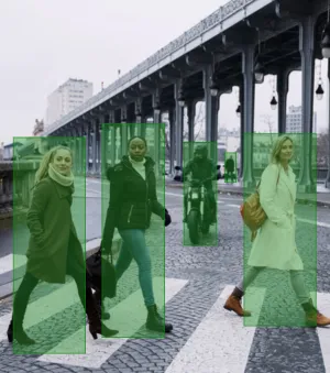
Bounding Box Annotation

Polygon Annotation
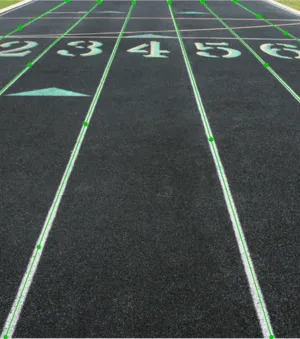
Polyline Annotation

3D Cuboids

Semantic Segmentation
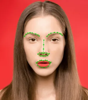
Point Annotation

Video Annotation
Have a usecase or data requirement?
Book a free consultation call today with one our Experts and explore endless possibilities.